These three terrain features are quite common across much of the whitetail’s range, but few hunters look for them. Here’s how to find and capitalize on these overlooked locations.
By Bernie Barringer
All serious whitetail hunters live for that magical time of the year; those three weeks in November when something amazing can happen at any moment. Bucks are on their feet at any hour of the day or night. Things like core areas and home ranges become meaningless as the mature males of the species pant and sweat and grind out the hours, searching for receptive females in a frantic effort to procreate during this short period of frenzied rutting activity. There is no better time to shoot the biggest buck of your life.
You wait for this window of opportunity all year. Don’t spend it in the wrong spot.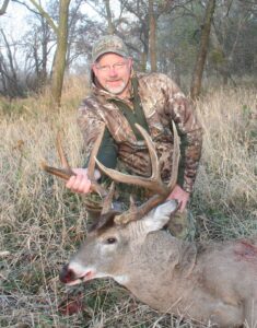
I hate that I spent so much of my life sitting in the wrong tree, but that is the nature of learning. Back in the 1970’s growing up in Iowa, I had no idea the potential that I had available at my fingertips. While I lived in the wrong part of the state for consistently producing big bucks, the big bucks were within reach; only a couple hours’ drive away.
But it took a long time to figure out how to put one of them in front of me. I would find a beaten-down trail or an area torn up with rubs and scrapes; then put up a stand. By the 1990’s I was finally beginning to figure it out. I finally killed a couple really nice ones and today, I travel all around the Midwest looking for mature bucks every year. My frenzy of rushing from state to state, putting up and taking down stands, checking trail cameras and walking miles and miles looking for fresh activity resembles the buck’s rutting activity for those three magical weeks.
But I have learned to be more efficient, and because I mostly hunt public land, I often find that the best-looking, obvious spots already have a treestand when I get there, and in many cases, have so much sign of human activity that the mature bucks of the area have learned to avoid them.
Before hunting any area, I spend some time looking over aerial photographs on Google Earth to find potential stand sites. Then, upon arrival, I look them over in person, taking note of the sign and the lay of the land. I want to know that when I put up a stand, it will be in a location that I can sit for a long period of time and the only way a fidgety guy like me can park his butt in a treestand all day is by having a supreme confidence that I am in a really great spot.
Particularly on those public areas and other lands that get a fair amount of hunting pressure, that spot is likely to be a site that most other hunters wouldn’t recognize. Here are brief descriptions of three great hunting spots that most hunters would overlook.
River Bends
I killed a 6-year-old buck on public land in Iowa a couple years ago on the 12th day of my seven-day hunt. I found a lot of sign of deer activity on the outside of a large, sweeping river bend on the fifth day of the hunt. Once in a stand, I began to see deer movement including one nice shooter buck, but most of the movement was out of range, so I had to adjust a couple times. I had moved my stand about 100 yards twice over the next few days before I settled on the exact spot where I killed that old warrior. The location was where the outside bend of a river swept up against a steep bluff, which funneled the deer movement into a narrow corridor. This was a river that the deer could easily cross, in fact they can cross any river if they want to bad enough, but they much preferred to take the long way around and a distinct trail developed on a shelf along the steep bank.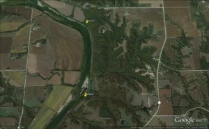
Deer, like all animals take the path of least resistance when travelling. They are looking for places that it is easy to walk and that’s where the trails develop. Any shelf along the riverbank from the top to the bottom of the step bluff will have a distinct trail on it, and it will have the tracks of not only deer, but those of raccoons, coyotes, and all critters that roam the forest, because they all prefer to travel the easy route.
This was a perfect place to intercept a buck that was pounding the pavement because it very naturally channeled the deer movement into a narrow area, an area where I could easily cover with a treestand in the right spot.
Jumpers
I kind of lucked onto this type of location. I happened to see a buck come out of the tip of a draw 100 yards away when I was sitting in a treestand in a bushy fencerow. I rattled at him, but after a short look towards me, he crossed the top of the hill and entered the point of a draw on the other side. After that morning’s hunt, I walked over there and was surprised to see a series of rubs and a small trail with several sets of big tracks in it. I realized that it was a perfect place for a buck to jump from one drainage to another with minimal exposure. He was only in the open for a very short period; it was an ideal shortcut.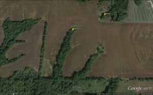
Frankly I don’t know of very many people who hunt these places I came to identify as “Jumpers,” but they can be absolutely dynamite if you find one in the right spot. These drainages may be referred to as hollows, ditches, draws or ravines depending on the local jargon, They are all checked by bucks cruising for receptive does. The place where an arm of the ravine reaches out into a field near where an arm of the adjacent ravine comes out will be used as a crossing point for bucks moving from one to the other.
You absolutely have to burn the booth leather to find the good ones. Looking at an aerial photo will give you dozens of these to check out, and most will have little to no sign, but when you find the one the bucks really like to use, you will know it. Rubs, tracks and often a scrape or two will be the tip-off that you are in the right spot.
The wind can be tricky in these locations; it tends to swirl and dance and it will fool you often. Hunt these spots carefully and only with a light wind. One of my favorite places to hunt these is where the trail coming down the arm of the ravine intersects the main trail going down the middle of the ravine. This may be down the slope a distance where usually the wind is friendlier.
Field Corners
In keeping with the theme that bucks do not like to expose themselves in the open any more than is absolutely necessary, the corners of fields are another overlooked stand site. These are basic and simple locations, easy to identify on an aerial photo or a topographical map. Heck, you can even see them from the road many times. They are everywhere in farm country.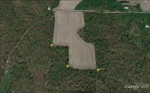
We are talking about the square corner of an open field that has woods on at least two sides of it. Because they do not like to cross open areas in the daylight, bucks will travel around the point, keeping just inside the woods. This creates a pinch point of sorts that concentrates their travel patterns. These pinch points up your odds of being within range of a buck by funneling their activity into a small area. Bucks also use them when scent-checking the field; they will cruise around the downwind side of a field to smell what does and other bucks may be in the field.
Interestingly, these places can have lots of sign or little to no sign and it doesn’t seem to make much difference during the rut. For some reason, I have seen these areas all torn up with rubs and scrapes or, on the other end of the spectrum, maybe just a very faint trail. The amount of sign in these areas seems to have no relation to the amount of travel they get when the bucks get on their feet and begin cruising.
I like to start monitoring these locations with trail cameras the end of October, which helps me learn which ones are getting the most use. I have found that if there is a lot of food in the area, say for example that the open field is corn stubble or alfalfa, the area will hold more does and be more conducive to bucks moving around the field corners. Once the field is plowed up and the does are feeding and bedding elsewhere, the amount of travel around the corner may drop off considerably.
Because I hunt mostly public lands which receive a lot of pressure from other hunters, I have found that the most obvious funnels, pinch points and areas with rutting sign get so much attention that the bucks soon learn to avoid them. If you learn to look for those less obvious points that concentrate the travel of cruising bucks, you can take advantage of not only the rut movement, but the tendencies of bucks to avoid the other hunters. This will help you put yourself in a much better position to bag a big one.
Using Google Earth and mapping apps
The advent of online aerial photography has been one of the greatest scouting tools ever. It has significantly changed the way hunters can research an area before ever seeing it in person. Great locations often jump right off the computer screen at you. These resources include online aerials such as Google Earth, Bing Maps and great apps for your device such as Scoutlook Weather and OnX maps. I have found that many of those locations only look good “on paper.” You have to get out there and walk them out, looking them over in person. Some of the spots that barely seemed worth a second look turned out to be some of my most consistent producers.
I believe one of the reasons that terrific spots on the screen turn out to be disappointments is because the aerial photography can’t show land relief well. Bucks travel based not only on terrain features such as woodlots and fields, but also on topography. You simply cannot read topography well on the computer screen. You have to have your feet on the ground to complete the puzzle.
For this reason, I recommend picking twice as many great looking spots from the computer screen as you think you will need. Some of them will disappoint upon arrival, but one or two of them may turn out to be the scene of your great elation when you walk up on the buck of a lifetime.